


Lamanon Sce St Denis

jymrando
User
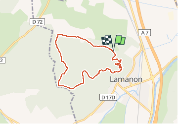

Length
7.6 km

Max alt
283 m

Uphill gradient
219 m
Km-Effort
10.6 km

Min alt
114 m

Downhill gradient
221 m
Boucle
Yes
Creation date :
2014-12-10 00:00:00.0
Updated on :
2014-12-10 00:00:00.0
2h14
Difficulty : Easy

FREE GPS app for hiking
 SityTrail
IGN / Geographical institutes
SityTrail Plus
The world is yours!
About
Trail Walking of 7.6 km to be discovered at Provence-Alpes-Côte d'Azur, Bouches-du-Rhône, Lamanon. This trail is proposed by jymrando.
Description
Montée au Défens en passant par les grottes de Calés.
Positioning
Country:
France
Region :
Provence-Alpes-Côte d'Azur
Department/Province :
Bouches-du-Rhône
Municipality :
Lamanon
Location:
Unknown
Start:(Dec)
Start:(UTM)
667742 ; 4841616 (31T) N.
Comments