


corona 2

NickPluym
User
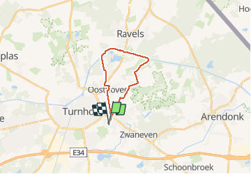

Length
15.8 km

Max alt
39 m

Uphill gradient
88 m
Km-Effort
16.9 km

Min alt
18 m

Downhill gradient
89 m
Boucle
Yes
Creation date :
2020-04-18 07:23:45.601
Updated on :
2020-04-18 11:00:25.522
3h34
Difficulty : Very easy

FREE GPS app for hiking
 SityTrail
IGN / Geographical institutes
SityTrail Plus
The world is yours!
About
Trail Walking of 15.8 km to be discovered at Flanders, Antwerp, Oud-Turnhout. This trail is proposed by NickPluym.
Positioning
Country:
Belgium
Region :
Flanders
Department/Province :
Antwerp
Municipality :
Oud-Turnhout
Location:
Oud-Turnhout
Start:(Dec)
Start:(UTM)
637617 ; 5686787 (31U) N.
Comments