


Belle mare

sameja
User
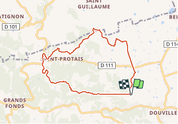

Length
12 km

Max alt
107 m

Uphill gradient
287 m
Km-Effort
15.9 km

Min alt
21 m

Downhill gradient
286 m
Boucle
Yes
Creation date :
2020-04-18 10:25:04.0
Updated on :
2020-04-18 13:36:46.477
1h52
Difficulty : Very difficult

FREE GPS app for hiking
 SityTrail
IGN / Geographical institutes
SityTrail Plus
The world is yours!
About
Trail Nordic walking of 12 km to be discovered at Guadeloupe, Unknown, Sainte-Anne. This trail is proposed by sameja.
Description
Route de liard saint Robert
Photos

Positioning
Country:
France
Region :
Guadeloupe
Department/Province :
Unknown
Municipality :
Sainte-Anne
Location:
Unknown
Start:(Dec)
Start:(UTM)
672437 ; 1799143 (20Q) N.
Comments