Trail Walking Saint-Parthem - 2020_07_Saint Parthem_Terra Olt - Photo

2020_07_Saint Parthem_Terra Olt

© OpenStreetMap contributors
Length
Length
12.3 km
Max alt
Max alt
458 m
Uphill gradient
Uphill gradient
427 m
Km-Effort
Km-Effort  
18 km
Min alt
Min alt
189 m
Downhill gradient
Downhill gradient
429 m
Boucle
Boucle
Yes
Creation date :
2020-04-19 13:44:08.543
Updated on :
2020-04-19 13:45:49.823

(0 Reviews)

Walking
Walking
2h30
Difficulty : Medium

Scan this QR Code to open this trail in the SityTrail application

FREE GPS app for hiking

Logo SityTrail SityTrail

IGN / Geographical institutes

Download SityTrail from the App Store Download SityTrail from Google Play

Logo SityTrail SityTrail World

The world is yours!

Download SityTrail from the App Store Download SityTrail from Google Play Download SityTrail on Huawei AppGallery

About

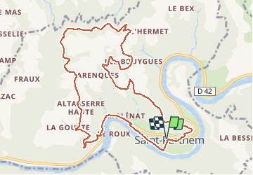
Trail Walking of 12.3 km to be discovered at Occitania, Aveyron, Saint-Parthem. This trail is proposed by jeanlucien.

Description

Balisage jaune
Donnée pour 03:45
Variante plus courte : 10.5 km et 03:00

Elevation profile

Positioning

Country:
France
Region :
Occitania
Department/Province :
Aveyron
Municipality :
Saint-Parthem
Location:
Unknown
Start:(UTM)
445549 ; 4941688 (31T) N.

Trails nearby

Trail Walking Conques-en-Rouergue - Les Pelies La Vinzelle : boucle rapide - Photo
Walking
lullaby92

Walking

Easy
(1)
Conques-en-Rouergue, Occitania, Aveyron, France
5.4 km | 8.8 km-effort
3h 19min
Yes
Trail Walking Conques-en-Rouergue - La Vinzelle - Grand Vabre - Photo
Walking
tracegps

Walking

Medium
(3)
Conques-en-Rouergue, Occitania, Aveyron, France
6.7 km | 11.1 km-effort
3h 30min
Yes
Trail On foot Conques-en-Rouergue - Terra trail 10 - Photo
On foot
PRO

On foot

Difficult
Conques-en-Rouergue, Occitania, Aveyron, France
22 km | 34 km-effort
7h 41min
Yes
Trail On foot Conques-en-Rouergue - Tieulet - Photo
On foot
PRO

On foot

Easy
(1)
Conques-en-Rouergue, Occitania, Aveyron, France
6.6 km | 10.5 km-effort
2h 22min
No
Trail Walking Conques-en-Rouergue - Sentier de Dadon - Grand Vabre - Photo
Walking
tracegps

Walking

Difficult
Conques-en-Rouergue, Occitania, Aveyron, France
19.9 km | 32 km-effort
7h 0min
Yes
Trail Walking Cassaniouze - vinzelle  - Photo
Walking
Delmasjacques

Walking

Very easy
Cassaniouze, Auvergne-Rhône-Alpes, Cantal, France
6.2 km | 10.9 km-effort
3h 34min
Yes
Trail Walking Conques-en-Rouergue - Grand Vabre - Photo
Walking
gcournac

Walking

Very difficult
Conques-en-Rouergue, Occitania, Aveyron, France
21 km | 33 km-effort
5h 49min
Yes
Trail Walking Conques-en-Rouergue - grand vabre - vinzelle  - grand vabre - Photo
Walking
lascap12

Walking

Very difficult
Conques-en-Rouergue, Occitania, Aveyron, France
21 km | 32 km-effort
4h 57min
Yes
Trail Walking Saint-Parthem - Port d'Agres - Photo
Walking
topophil

Walking

Very difficult
Saint-Parthem, Occitania, Aveyron, France
16.1 km | 22 km-effort
4h 33min
No


Close
My subscriptions