


marche du 20 04 20 - 4.2 a 37

jtraverse
User
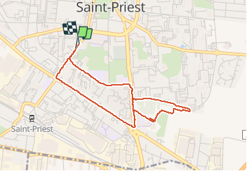

Length
4.2 km

Max alt
229 m

Uphill gradient
37 m
Km-Effort
4.6 km

Min alt
207 m

Downhill gradient
36 m
Boucle
Yes
Creation date :
2020-04-20 13:43:26.45
Updated on :
2020-05-16 15:59:56.046
59m
Difficulty : Easy

FREE GPS app for hiking
 SityTrail
IGN / Geographical institutes
SityTrail Plus
The world is yours!
About
Trail Walking of 4.2 km to be discovered at Auvergne-Rhône-Alpes, Métropole de Lyon, Saint-Priest. This trail is proposed by jtraverse.
Positioning
Country:
France
Region :
Auvergne-Rhône-Alpes
Department/Province :
Métropole de Lyon
Municipality :
Saint-Priest
Location:
Unknown
Start:(Dec)
Start:(UTM)
651032 ; 5061756 (31T) N.
Comments