


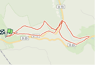
SURCENEUXPEUTE BASSE SURCENEUX

surceneux
User

Length
5.6 km

Max alt
896 m

Uphill gradient
238 m
Km-Effort
8.8 km

Min alt
752 m

Downhill gradient
240 m
Boucle
Yes
Creation date :
2020-04-22 08:52:43.425
Updated on :
2020-04-22 10:06:20.088
55m
Difficulty : Medium

FREE GPS app for hiking
 SityTrail
IGN / Geographical institutes
SityTrail Plus
The world is yours!
About
Trail Running of 5.6 km to be discovered at Grand Est, Vosges, Ban-sur-Meurthe-Clefcy. This trail is proposed by surceneux.
Description
PEUTE BASSE SCHMALICK CALVAIRE CROIX MALTETE ROSE BIS SURCENEUX
Positioning
Country:
France
Region :
Grand Est
Department/Province :
Vosges
Municipality :
Ban-sur-Meurthe-Clefcy
Location:
Unknown
Start:(Dec)
Start:(UTM)
347873 ; 5329055 (32U) N.
Comments