


Confinement

gil05
User

Length
3.6 km

Max alt
996 m

Uphill gradient
102 m
Km-Effort
4.9 km

Min alt
901 m

Downhill gradient
104 m
Boucle
Yes
Creation date :
2020-04-22 13:28:32.0
Updated on :
2020-04-22 14:40:07.943
1h08
Difficulty : Easy

FREE GPS app for hiking
 SityTrail
IGN / Geographical institutes
SityTrail Plus
The world is yours!
About
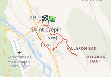
Trail Walking of 3.6 km to be discovered at Provence-Alpes-Côte d'Azur, Hautes-Alpes, Saint-Crépin. This trail is proposed by gil05.
Description
Tour du village
Positioning
Country:
France
Region :
Provence-Alpes-Côte d'Azur
Department/Province :
Hautes-Alpes
Municipality :
Saint-Crépin
Location:
Unknown
Start:(Dec)
Start:(UTM)
310487 ; 4953192 (32T) N.
Comments