Trail On foot Saint-Sauvy - trail cote 12*30 - Photo

trail cote 12*30

© OpenStreetMap contributors
Length
Length
8.9 km
Max alt
Max alt
210 m
Uphill gradient
Uphill gradient
128 m
Km-Effort
Km-Effort  
10.6 km
Min alt
Min alt
136 m
Downhill gradient
Downhill gradient
127 m
Boucle
Boucle
Yes
Creation date :
2020-04-24 17:22:07.726
Updated on :
2020-05-02 14:51:15.283

(0 Reviews)

On foot
On foot
1h40
Difficulty : Very easy
Running
Running
45m
Difficulty : Very easy
Trail
Trail
45m
Difficulty : Very easy

Scan this QR Code to open this trail in the SityTrail application

FREE GPS app for hiking

Logo SityTrail SityTrail

IGN / Geographical institutes

Download SityTrail from the App Store Download SityTrail from Google Play

Logo SityTrail SityTrail World

The world is yours!

Download SityTrail from the App Store Download SityTrail from Google Play Download SityTrail on Huawei AppGallery

About

Trail On foot of 8.9 km to be discovered at Occitania, Gers, Saint-Sauvy. This trail is proposed by jeromelacoste.

Description

Parcours mixte chemin goudronnée et sentier dans les bois.

Elevation profile

Photos

Positioning

Country:
France
Region :
Occitania
Department/Province :
Gers
Municipality :
Saint-Sauvy
Location:
Unknown
Start:(UTM)
324315 ; 4840266 (31T) N.

Trails nearby

Trail On foot Mauvezin - Wikiloc - Mauvezin Le Gouffre de La Hobio - Photo
On foot
jeromelacoste

On foot

Easy
(1)
Mauvezin, Occitania, Gers, France
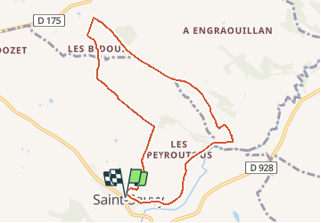
15.1 km | 18.8 km-effort
Unknown
Yes
Trail Running Mauvezin - Ronde des foies gras - Mauvezin - Photo
Running
tracegps

Running

Difficult
Mauvezin, Occitania, Gers, France
25 km | 29 km-effort
3h 0min
No
Trail Mountain bike Mauvezin - Ronde des foies gras - Mauvezin - Photo
Mountain bike
tracegps

Mountain bike

Medium
Mauvezin, Occitania, Gers, France
25 km | 29 km-effort
2h 0min
No
Trail Walking Saint-Antonin - Marie vers Saint sauvy - Photo
Walking
yves31

Walking

Very easy
Saint-Antonin, Occitania, Gers, France
5.8 km | 6.7 km-effort
1h 28min
No
Trail Mountain bike Mauvezin - Randonnée VTT - Mauvezin - Photo
Mountain bike
tracegps

Mountain bike

Medium
Mauvezin, Occitania, Gers, France
15.5 km | 18.3 km-effort
1h 10min
Yes
Trail Walking Mauvezin - Mauvezin-Hobio-14446683 - Photo
Walking
pidjam

Walking

Very difficult
Mauvezin, Occitania, Gers, France
16.2 km | 20 km-effort
4h 36min
Yes
Trail Walking Mauvezin - Mauvezin délices Isabelle fait - Photo
Walking
cmcmuriel.augier

Walking

Very difficult
(1)
Mauvezin, Occitania, Gers, France
17.8 km | 22 km-effort
4h 14min
No
Trail On foot Mauvezin - Moulin de dodet mauvezin - Photo
On foot
jeromelacoste

On foot

Very easy
Mauvezin, Occitania, Gers, France
11.3 km | 13.3 km-effort
Unknown
Yes
Trail On foot Mauvezin - Wikiloc - Mauvezin - Photo
On foot
jeromelacoste

On foot

Very easy
Mauvezin, Occitania, Gers, France
6.1 km | 7.3 km-effort
Unknown
Yes


Close
My subscriptions