


Randonnette confinette 26 04 2020

jesusmarieclaire
User
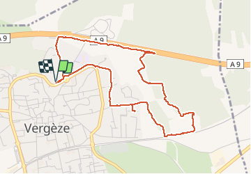

Length
5.2 km

Max alt
51 m

Uphill gradient
50 m
Km-Effort
5.8 km

Min alt
22 m

Downhill gradient
49 m
Boucle
Yes
Creation date :
2020-04-26 07:48:05.12
Updated on :
2020-04-26 09:00:20.832
1h09
Difficulty : Very easy

FREE GPS app for hiking
 SityTrail
IGN / Geographical institutes
SityTrail Plus
The world is yours!
About
Trail Walking of 5.2 km to be discovered at Occitania, Gard, Vergèze. This trail is proposed by jesusmarieclaire.
Description
Rando
Positioning
Country:
France
Region :
Occitania
Department/Province :
Gard
Municipality :
Vergèze
Location:
Unknown
Start:(Dec)
Start:(UTM)
598356 ; 4844465 (31T) N.
Comments