


tour vallon des fleurs

lionel4806
User
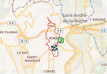

Length
5.5 km

Max alt
189 m

Uphill gradient
170 m
Km-Effort
7.8 km

Min alt
98 m

Downhill gradient
169 m
Boucle
No
Creation date :
2020-04-29 05:24:55.015
Updated on :
2020-04-29 07:00:21.907
46m
Difficulty : Very easy

FREE GPS app for hiking
 SityTrail
IGN / Geographical institutes
SityTrail Plus
The world is yours!
About
Trail Running of 5.5 km to be discovered at Provence-Alpes-Côte d'Azur, Maritime Alps, Nice. This trail is proposed by lionel4806.
Description
vallon
Positioning
Country:
France
Region :
Provence-Alpes-Côte d'Azur
Department/Province :
Maritime Alps
Municipality :
Nice
Location:
Unknown
Start:(Dec)
Start:(UTM)
361214 ; 4842776 (32T) N.
Comments