


Pointe du diable

YCDBSOYA
User

Length
3.8 km

Max alt
21 m

Uphill gradient
35 m
Km-Effort
4.3 km

Min alt
5 m

Downhill gradient
35 m
Boucle
Yes
Creation date :
2020-05-01 06:19:44.0
Updated on :
2020-05-01 07:26:29.609
1h03
Difficulty : Easy

FREE GPS app for hiking
 SityTrail
IGN / Geographical institutes
SityTrail Plus
The world is yours!
About
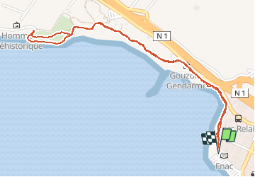
Trail Walking of 3.8 km to be discovered at Réunion, Unknown, Saint-Pierre. This trail is proposed by YCDBSOYA.
Description
Littoral océan
Positioning
Country:
France
Region :
Réunion
Department/Province :
Unknown
Municipality :
Saint-Pierre
Location:
Unknown
Start:(Dec)
Start:(UTM)
339757 ; 7640066 (40K) S.
Comments