


chemin lombardie vers st andre

lionel4806
User
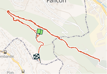

Length
4.3 km

Max alt
233 m

Uphill gradient
158 m
Km-Effort
6.3 km

Min alt
70 m

Downhill gradient
125 m
Boucle
No
Creation date :
2020-05-02 06:54:48.917
Updated on :
2020-05-02 09:42:39.521
2h05
Difficulty : Very easy

FREE GPS app for hiking
 SityTrail
IGN / Geographical institutes
SityTrail Plus
The world is yours!
About
Trail Walking of 4.3 km to be discovered at Provence-Alpes-Côte d'Azur, Maritime Alps, Falicon. This trail is proposed by lionel4806.
Description
st andre
Positioning
Country:
France
Region :
Provence-Alpes-Côte d'Azur
Department/Province :
Maritime Alps
Municipality :
Falicon
Location:
Unknown
Start:(Dec)
Start:(UTM)
361201 ; 4845012 (32T) N.
Comments