


aire st michel

lionel4806
User
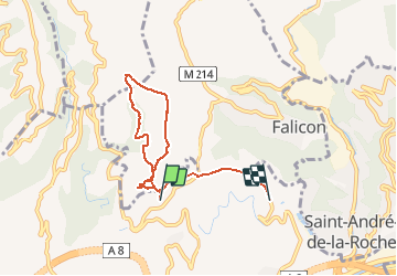

Length
6.2 km

Max alt
491 m

Uphill gradient
178 m
Km-Effort
8.8 km

Min alt
270 m

Downhill gradient
240 m
Boucle
No
Creation date :
2020-05-03 06:41:07.929
Updated on :
2020-05-03 09:56:11.44
1h56
Difficulty : Very easy

FREE GPS app for hiking
 SityTrail
IGN / Geographical institutes
SityTrail Plus
The world is yours!
About
Trail Walking of 6.2 km to be discovered at Provence-Alpes-Côte d'Azur, Maritime Alps, Nice. This trail is proposed by lionel4806.
Positioning
Country:
France
Region :
Provence-Alpes-Côte d'Azur
Department/Province :
Maritime Alps
Municipality :
Nice
Location:
Unknown
Start:(Dec)
Start:(UTM)
359695 ; 4844563 (32T) N.
Comments