


Baudemont Ittre

JLD
User
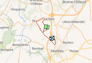

Length
12.6 km

Max alt
145 m

Uphill gradient
211 m
Km-Effort
15.5 km

Min alt
75 m

Downhill gradient
211 m
Boucle
No
Creation date :
2020-05-03 09:04:00.0
Updated on :
2020-05-03 11:22:17.536
2h17
Difficulty : Unknown

FREE GPS app for hiking
 SityTrail
IGN / Geographical institutes
SityTrail Plus
The world is yours!
About
Trail Walking of 12.6 km to be discovered at Wallonia, Walloon Brabant, Ittre. This trail is proposed by JLD.
Positioning
Country:
Belgium
Region :
Wallonia
Department/Province :
Walloon Brabant
Municipality :
Ittre
Location:
Ittre
Start:(Dec)
Start:(UTM)
590979 ; 5609418 (31U) N.
Comments