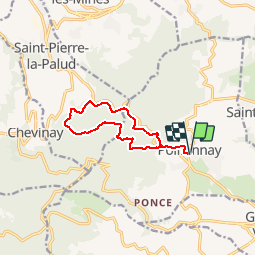
69 POLLIONNAY Les Pins des Marollieres

trietsch
User

Length
10.3 km

Max alt
718 m

Uphill gradient
449 m
Km-Effort
16.3 km

Min alt
428 m

Downhill gradient
450 m
Boucle
Yes
Creation date :
2014-12-10 00:00:00.0
Updated on :
2020-01-04 20:30:42.053
3h00
Difficulty : Medium

FREE GPS app for hiking
 SityTrail
IGN / Geographical institutes
SityTrail Plus
The world is yours!
About
Trail Walking of 10.3 km to be discovered at Auvergne-Rhône-Alpes, Rhône, Pollionnay. This trail is proposed by trietsch.
Description
Senes inverse montre
Balisage rouge
Positioning
Country:
France
Region :
Auvergne-Rhône-Alpes
Department/Province :
Rhône
Municipality :
Pollionnay
Location:
Unknown
Start:(Dec)
Start:(UTM)
629136 ; 5069270 (31T) N.
Comments