


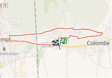
Colombe 1

mireillemarmonier
User

Length
4.7 km

Max alt
522 m

Uphill gradient
76 m
Km-Effort
5.8 km

Min alt
461 m

Downhill gradient
78 m
Boucle
Yes
Creation date :
2020-05-03 14:45:20.0
Updated on :
2020-05-03 15:46:16.108
1h01
Difficulty : Easy

FREE GPS app for hiking
 SityTrail
IGN / Geographical institutes
SityTrail Plus
The world is yours!
About
Trail Walking of 4.7 km to be discovered at Auvergne-Rhône-Alpes, Isère, Colombe. This trail is proposed by mireillemarmonier.
Description
Marche confinement 1 h
Positioning
Country:
France
Region :
Auvergne-Rhône-Alpes
Department/Province :
Isère
Municipality :
Colombe
Location:
Unknown
Start:(Dec)
Start:(UTM)
690855 ; 5029935 (31T) N.
Comments