


BBRIETTE ETANG

surceneux
User
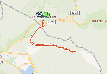

Length
6.8 km

Max alt
840 m

Uphill gradient
161 m
Km-Effort
8.9 km

Min alt
797 m

Downhill gradient
161 m
Boucle
Yes
Creation date :
2020-05-08 09:00:16.174
Updated on :
2020-05-08 13:11:27.468
52m
Difficulty : Very easy

FREE GPS app for hiking
 SityTrail
IGN / Geographical institutes
SityTrail Plus
The world is yours!
About
Trail Running of 6.8 km to be discovered at Grand Est, Vosges, Ban-sur-Meurthe-Clefcy. This trail is proposed by surceneux.
Description
BELBRIETTE ETANG AR
Positioning
Country:
France
Region :
Grand Est
Department/Province :
Vosges
Municipality :
Ban-sur-Meurthe-Clefcy
Location:
Unknown
Start:(Dec)
Start:(UTM)
347790 ; 5328982 (32U) N.
Comments