


huit Chp haut

Yannick.Boireau
User
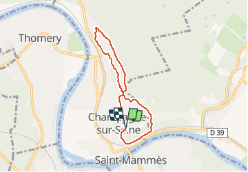

Length
5.8 km

Max alt
112 m

Uphill gradient
75 m
Km-Effort
6.8 km

Min alt
67 m

Downhill gradient
77 m
Boucle
Yes
Creation date :
2020-05-09 14:35:40.56
Updated on :
2020-05-09 16:17:50.811
1h38
Difficulty : Very easy

FREE GPS app for hiking
 SityTrail
IGN / Geographical institutes
SityTrail Plus
The world is yours!
About
Trail Walking of 5.8 km to be discovered at Ile-de-France, Seine-et-Marne, Champagne-sur-Seine. This trail is proposed by Yannick.Boireau.
Positioning
Country:
France
Region :
Ile-de-France
Department/Province :
Seine-et-Marne
Municipality :
Champagne-sur-Seine
Location:
Unknown
Start:(Dec)
Start:(UTM)
485661 ; 5360073 (31U) N.
Comments