


BL Hauenstein / Bölchenfluh

hrb
User
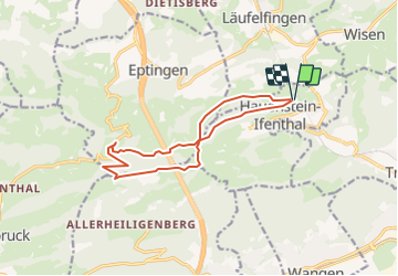

Length
12.7 km

Max alt
1064 m

Uphill gradient
503 m
Km-Effort
19.4 km

Min alt
696 m

Downhill gradient
510 m
Boucle
Yes
Creation date :
2014-12-11 00:00:00.0
Updated on :
2014-12-11 00:00:00.0
--
Difficulty : Unknown

FREE GPS app for hiking
 SityTrail
IGN / Geographical institutes
SityTrail Plus
The world is yours!
About
Trail Other activity of 12.7 km to be discovered at Solothurn, Bezirk Gösgen, Hauenstein-Ifenthal. This trail is proposed by hrb.
Description
Ev. besser Start in Le Signal
Châlet dernier im Sommer eine Beiz
Positioning
Country:
Switzerland
Region :
Solothurn
Department/Province :
Bezirk Gösgen
Municipality :
Hauenstein-Ifenthal
Location:
Unknown
Start:(Dec)
Start:(UTM)
414259 ; 5247826 (32T) N.
Comments