


Clermont_Cotes_Bancillon

jagarnier
User GUIDE
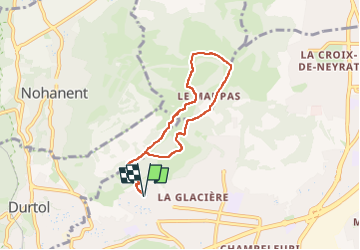

Length
6.1 km

Max alt
618 m

Uphill gradient
237 m
Km-Effort
9.3 km

Min alt
461 m

Downhill gradient
237 m
Boucle
Yes
Creation date :
2020-05-11 05:07:44.98
Updated on :
2024-06-28 04:47:32.209
1h45
Difficulty : Medium

FREE GPS app for hiking
 SityTrail
IGN / Geographical institutes
SityTrail Plus
The world is yours!
About
Trail Walking of 6.1 km to be discovered at Auvergne-Rhône-Alpes, Puy-de-Dôme, Clermont-Ferrand. This trail is proposed by jagarnier.
Photos

Positioning
Country:
France
Region :
Auvergne-Rhône-Alpes
Department/Province :
Puy-de-Dôme
Municipality :
Clermont-Ferrand
Location:
Unknown
Start:(Dec)
Start:(UTM)
505587 ; 5071442 (31T) N.
Comments