


Terre Sainte

YCDBSOYA
User
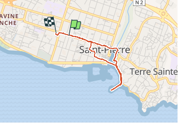

Length
4.1 km

Max alt
27 m

Uphill gradient
39 m
Km-Effort
4.7 km

Min alt
2 m

Downhill gradient
44 m
Boucle
No
Creation date :
2020-05-11 10:54:56.0
Updated on :
2020-05-11 12:31:08.146
1h13
Difficulty : Easy

FREE GPS app for hiking
 SityTrail
IGN / Geographical institutes
SityTrail Plus
The world is yours!
About
Trail Walking of 4.1 km to be discovered at Réunion, Unknown, Saint-Pierre. This trail is proposed by YCDBSOYA.
Description
Ballade dans Saint Pierre
Positioning
Country:
France
Region :
Réunion
Department/Province :
Unknown
Municipality :
Saint-Pierre
Location:
Unknown
Start:(Dec)
Start:(UTM)
341483 ; 7639556 (40K) S.
Comments