


Hennebont deconfinement2

macada
User
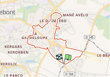

Length
4.4 km

Max alt
62 m

Uphill gradient
53 m
Km-Effort
5.1 km

Min alt
26 m

Downhill gradient
51 m
Boucle
Yes
Creation date :
2020-05-11 11:32:25.752
Updated on :
2020-11-04 09:06:43.042
26m
Difficulty : Very easy

FREE GPS app for hiking
 SityTrail
IGN / Geographical institutes
SityTrail Plus
The world is yours!
About
Trail Walking of 4.4 km to be discovered at Brittany, Morbihan, Hennebont. This trail is proposed by macada.
Photos


Positioning
Country:
France
Region :
Brittany
Department/Province :
Morbihan
Municipality :
Hennebont
Location:
Unknown
Start:(Dec)
Start:(UTM)
480751 ; 5293654 (30T) N.
Comments