


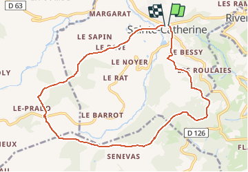
69 Sainte Catherine

trietsch
User

Length
9.8 km

Max alt
864 m

Uphill gradient
304 m
Km-Effort
13.9 km

Min alt
676 m

Downhill gradient
307 m
Boucle
Yes
Creation date :
2020-05-11 14:43:21.622
Updated on :
2020-05-11 14:50:28.111
2h55
Difficulty : Difficult

FREE GPS app for hiking
 SityTrail
IGN / Geographical institutes
SityTrail Plus
The world is yours!
About
Trail Walking of 9.8 km to be discovered at Auvergne-Rhône-Alpes, Rhône, Sainte-Catherine. This trail is proposed by trietsch.
Description
Possibilité à 2/3 du parcours de faire un Pic Nic à la chapelle avec tables et bancs
Positioning
Country:
France
Region :
Auvergne-Rhône-Alpes
Department/Province :
Rhône
Municipality :
Sainte-Catherine
Location:
Unknown
Start:(Dec)
Start:(UTM)
622451 ; 5050755 (31T) N.
Comments