


2020-05-12 Forêt de Taverny

Bernardb44
User
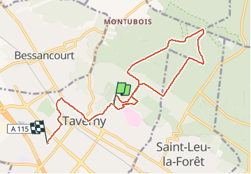

Length
8.6 km

Max alt
194 m

Uphill gradient
110 m
Km-Effort
10.3 km

Min alt
78 m

Downhill gradient
180 m
Boucle
No
Creation date :
2020-05-12 16:13:11.878
Updated on :
2020-05-12 19:40:35.963
3h26
Difficulty : Very easy

FREE GPS app for hiking
 SityTrail
IGN / Geographical institutes
SityTrail Plus
The world is yours!
About
Trail Walking of 8.6 km to be discovered at Ile-de-France, Val-d'Oise, Taverny. This trail is proposed by Bernardb44.
Positioning
Country:
France
Region :
Ile-de-France
Department/Province :
Val-d'Oise
Municipality :
Taverny
Location:
Unknown
Start:(Dec)
Start:(UTM)
443778 ; 5430990 (31U) N.
Comments