


Rec. Poitte-Largillay

drarep
User
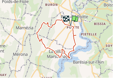

Length
13.7 km

Max alt
631 m

Uphill gradient
332 m
Km-Effort
18.1 km

Min alt
428 m

Downhill gradient
333 m
Boucle
Yes
Creation date :
2020-05-13 17:10:28.244
Updated on :
2020-05-13 17:11:49.42
3h51
Difficulty : Easy

FREE GPS app for hiking
 SityTrail
IGN / Geographical institutes
SityTrail Plus
The world is yours!
About
Trail Walking of 13.7 km to be discovered at Bourgogne-Franche-Comté, Jura, Pont-de-Poitte. This trail is proposed by drarep.
Positioning
Country:
France
Region :
Bourgogne-Franche-Comté
Department/Province :
Jura
Municipality :
Pont-de-Poitte
Location:
Unknown
Start:(Dec)
Start:(UTM)
706146 ; 5161637 (31T) N.
Comments