


Carpiagne / Luminy

jps13
User
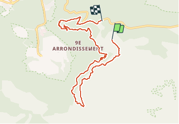

Length
9.9 km

Max alt
395 m

Uphill gradient
328 m
Km-Effort
14.5 km

Min alt
149 m

Downhill gradient
391 m
Boucle
No
Creation date :
2020-01-12 12:43:44.0
Updated on :
2020-05-14 12:47:42.72
2h32
Difficulty : Difficult

FREE GPS app for hiking
 SityTrail
IGN / Geographical institutes
SityTrail Plus
The world is yours!
About
Trail Walking of 9.9 km to be discovered at Provence-Alpes-Côte d'Azur, Bouches-du-Rhône, Marseille. This trail is proposed by jps13.
Description
Gros dénivelée, très belles vues calanques, îles, ville
Positioning
Country:
France
Region :
Provence-Alpes-Côte d'Azur
Department/Province :
Bouches-du-Rhône
Municipality :
Marseille
Location:
9th Arrondissement
Start:(Dec)
Start:(UTM)
699886 ; 4789923 (31T) N.
Comments