


NewTrack

djeepee74
User
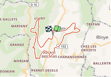

Length
9.6 km

Max alt
627 m

Uphill gradient
299 m
Km-Effort
13.5 km

Min alt
439 m

Downhill gradient
292 m
Boucle
Yes
Creation date :
2020-05-14 20:08:20.666
Updated on :
2020-05-16 19:51:15.923
2h45
Difficulty : Medium

FREE GPS app for hiking
 SityTrail
IGN / Geographical institutes
SityTrail Plus
The world is yours!
About
Trail Walking of 9.6 km to be discovered at Auvergne-Rhône-Alpes, Upper Savoy, Massingy. This trail is proposed by djeepee74.
Description
BOUCLE
Positioning
Country:
France
Region :
Auvergne-Rhône-Alpes
Department/Province :
Upper Savoy
Municipality :
Massingy
Location:
Unknown
Start:(Dec)
Start:(UTM)
726604 ; 5078896 (31T) N.
Comments