


VB Mauborget Nord

hrb
User
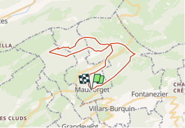

Length
14.6 km

Max alt
1425 m

Uphill gradient
538 m
Km-Effort
22 km

Min alt
1176 m

Downhill gradient
541 m
Boucle
Yes
Creation date :
2014-12-11 00:00:00.0
Updated on :
2014-12-11 00:00:00.0
--
Difficulty : Unknown

FREE GPS app for hiking
 SityTrail
IGN / Geographical institutes
SityTrail Plus
The world is yours!
About
Trail Other activity of 14.6 km to be discovered at Vaud, District du Jura-Nord vaudois, Mauborget. This trail is proposed by hrb.
Description
Ursprünglich war die Wanderung länger, aber die Wege entlang der Menthue waren saumässig verwildert!
Achtung: die Brücke bei Bois Dessous existierte am 2.05.2008 nicht mehr.
Positioning
Country:
Switzerland
Region :
Vaud
Department/Province :
District du Jura-Nord vaudois
Municipality :
Mauborget
Location:
Unknown
Start:(Dec)
Start:(UTM)
318138 ; 5191868 (32T) N.
Comments