


praly

sabine38
User
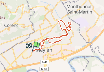

Length
8.9 km

Max alt
296 m

Uphill gradient
139 m
Km-Effort
10.7 km

Min alt
219 m

Downhill gradient
138 m
Boucle
Yes
Creation date :
2020-05-15 11:21:32.543
Updated on :
2020-05-15 13:04:59.179
1h36
Difficulty : Very easy

FREE GPS app for hiking
 SityTrail
IGN / Geographical institutes
SityTrail Plus
The world is yours!
About
Trail Walking of 8.9 km to be discovered at Auvergne-Rhône-Alpes, Isère, Meylan. This trail is proposed by sabine38.
Positioning
Country:
France
Region :
Auvergne-Rhône-Alpes
Department/Province :
Isère
Municipality :
Meylan
Location:
Unknown
Start:(Dec)
Start:(UTM)
717882 ; 5009883 (31T) N.
Comments