


cartayre ferme

lablaquiere
User

Length
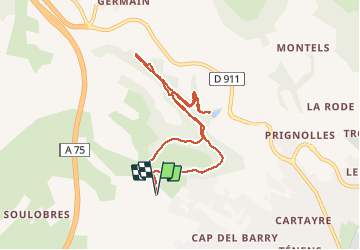
8.6 km

Max alt
599 m

Uphill gradient
290 m
Km-Effort
12.4 km

Min alt
456 m

Downhill gradient
290 m
Boucle
Yes
Creation date :
2020-05-09 06:03:13.148
Updated on :
2020-05-16 12:01:15.536
1h34
Difficulty : Very easy

FREE GPS app for hiking
 SityTrail
IGN / Geographical institutes
SityTrail Plus
The world is yours!
About
Trail Running of 8.6 km to be discovered at Occitania, Aveyron, Millau. This trail is proposed by lablaquiere.
Photos

Positioning
Country:
France
Region :
Occitania
Department/Province :
Aveyron
Municipality :
Millau
Location:
Unknown
Start:(Dec)
Start:(UTM)
503485 ; 4884386 (31T) N.
Comments