


Buvrinnes Epinois Buvrinnes

andremusin
User
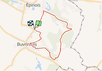

Length
7.1 km

Max alt
202 m

Uphill gradient
101 m
Km-Effort
8.5 km

Min alt
140 m

Downhill gradient
102 m
Boucle
Yes
Creation date :
2020-05-16 13:20:22.471
Updated on :
2020-05-17 06:29:22.397
1h25
Difficulty : Very easy

FREE GPS app for hiking
 SityTrail
IGN / Geographical institutes
SityTrail Plus
The world is yours!
About
Trail Walking of 7.1 km to be discovered at Wallonia, Hainaut, Binche. This trail is proposed by andremusin.
Positioning
Country:
Belgium
Region :
Wallonia
Department/Province :
Hainaut
Municipality :
Binche
Location:
Buvrinnes
Start:(Dec)
Start:(UTM)
586037 ; 5583291 (31U) N.
Comments