Trail Walking Verchaix - PED Bouchard > Valentine > Magnin - Photo

PED Bouchard > Valentine > Magnin

© OpenStreetMap contributors
Length
Length
2.3 km
Max alt
Max alt
1223 m
Uphill gradient
Uphill gradient
152 m
Km-Effort
Km-Effort  
4.4 km
Min alt
Min alt
1086 m
Downhill gradient
Downhill gradient
173 m
Boucle
Boucle
Yes
Creation date :
2020-05-17 08:43:55.915
Updated on :
2020-05-17 10:06:26.781

(0 Reviews)

Walking
Walking
1h22
Difficulty : Very easy

Scan this QR Code to open this trail in the SityTrail application

FREE GPS app for hiking

Logo SityTrail SityTrail

IGN / Geographical institutes

Download SityTrail from the App Store Download SityTrail from Google Play

Logo SityTrail SityTrail World

The world is yours!

Download SityTrail from the App Store Download SityTrail from Google Play Download SityTrail on Huawei AppGallery

About

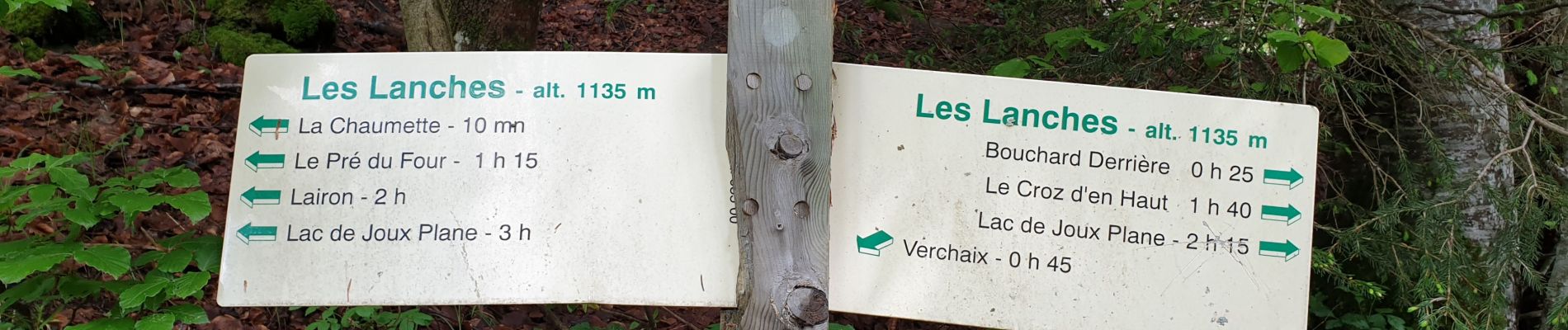
Trail Walking of 2.3 km to be discovered at Auvergne-Rhône-Alpes, Upper Savoy, Verchaix. This trail is proposed by BENOITPatrick52.

Description

Circuit court au départ des Lanches.
Passage limite dangereux à la descente sur le chemin vers Magnin qui domine la Valentine (accès éboulé).

Elevation profile

Photos

Positioning

Country:
France
Region :
Auvergne-Rhône-Alpes
Department/Province :
Upper Savoy
Municipality :
Verchaix
Location:
Unknown
Start:(UTM)
321140 ; 5108093 (32T) N.

Trails nearby

Trail Walking Samoëns - La Tête de Bostan - Photo
Walking
bourel.jacques

Walking

Medium
(2)
Samoëns, Auvergne-Rhône-Alpes, Upper Savoy, France
14.9 km | 32 km-effort
6h 32min
Yes
Trail Walking Samoëns - les chalets du Bémont et cascade du Nant d Ant - Photo
Walking
José800

Walking

Medium
Samoëns, Auvergne-Rhône-Alpes, Upper Savoy, France
6.7 km | 10.5 km-effort
2h 10min
No
Trail Walking Morillon - autour de Morillon 74 . - Photo
Walking
José800

Walking

Easy
Morillon, Auvergne-Rhône-Alpes, Upper Savoy, France
5.9 km | 7.9 km-effort
1h 51min
Yes
Trail Walking Samoëns - SAMOENS: LAC DES CHAMBRES - Photo
Walking
djeepee74

Walking

Difficult
Samoëns, Auvergne-Rhône-Alpes, Upper Savoy, France
14.2 km | 31 km-effort
6h 11min
Yes
Trail Walking Samoëns - SAMOENS: BOSTAN - GOLESE - Photo
Walking
djeepee74

Walking

Difficult
Samoëns, Auvergne-Rhône-Alpes, Upper Savoy, France
12.8 km | 24 km-effort
4h 51min
Yes
Trail Walking Verchaix - 74-Gets-chapelle-de Jacquicourt-4,8km-245m - Photo
Walking
SyMA

Walking

Very easy
Verchaix, Auvergne-Rhône-Alpes, Upper Savoy, France
4.8 km | 8.1 km-effort
2h 17min
Yes
Trail Walking Samoëns - Samoens . gorges des tines - retour  - Photo
Walking
stef789

Walking

Very easy
Samoëns, Auvergne-Rhône-Alpes, Upper Savoy, France
9.6 km | 12.9 km-effort
4h 1min
Yes
Trail Walking Verchaix - La Bourgeoise et la Pointe d'Angolon - Photo
Walking
GuyVachet

Walking

Difficult
Verchaix, Auvergne-Rhône-Alpes, Upper Savoy, France
7.7 km | 14.1 km-effort
5h 7min
Yes
Trail Walking Samoëns - en direction du Lac des Chambres  - Photo
Walking
GuyVachet

Walking

Difficult
Samoëns, Auvergne-Rhône-Alpes, Upper Savoy, France
11 km | 23 km-effort
6h 20min
Yes


Close
My subscriptions