


Chateau Saint Jean

pocoyo
User
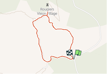

Length
2 km

Max alt
602 m

Uphill gradient
86 m
Km-Effort
3.1 km

Min alt
515 m

Downhill gradient
85 m
Boucle
Yes
Creation date :
2020-05-17 11:59:35.321
Updated on :
2020-05-17 12:00:11.927
38m
Difficulty : Easy

FREE GPS app for hiking
 SityTrail
IGN / Geographical institutes
SityTrail Plus
The world is yours!
About
Trail Walking of 2 km to be discovered at Provence-Alpes-Côte d'Azur, Var, Rougiers. This trail is proposed by pocoyo.
Positioning
Country:
France
Region :
Provence-Alpes-Côte d'Azur
Department/Province :
Var
Municipality :
Rougiers
Location:
Unknown
Start:(Dec)
Start:(UTM)
731379 ; 4806670 (31T) N.
Comments