


Vercors Dent de Moirans

c.gourme
User
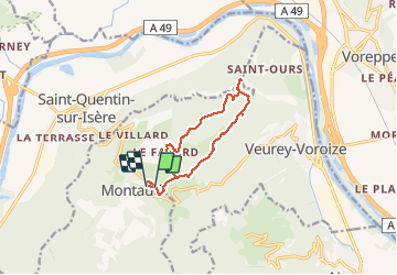

Length
11.6 km

Max alt
990 m

Uphill gradient
397 m
Km-Effort
16.9 km

Min alt
680 m

Downhill gradient
399 m
Boucle
Yes
Creation date :
2020-05-17 08:19:12.0
Updated on :
2020-05-17 13:13:08.018
3h49
Difficulty : Medium

FREE GPS app for hiking
 SityTrail
IGN / Geographical institutes
SityTrail Plus
The world is yours!
About
Trail Walking of 11.6 km to be discovered at Auvergne-Rhône-Alpes, Isère, Montaud. This trail is proposed by c.gourme.
Positioning
Country:
France
Region :
Auvergne-Rhône-Alpes
Department/Province :
Isère
Municipality :
Montaud
Location:
Unknown
Start:(Dec)
Start:(UTM)
701496 ; 5015466 (31T) N.
Comments