


croix/noraz

PatriceCocuaud
User

Length
3 km

Max alt
349 m

Uphill gradient
52 m
Km-Effort
3.7 km

Min alt
296 m

Downhill gradient
50 m
Boucle
Yes
Creation date :
2020-05-17 13:39:04.146
Updated on :
2020-05-17 14:36:24.827
56m
Difficulty : Very easy

FREE GPS app for hiking
 SityTrail
IGN / Geographical institutes
SityTrail Plus
The world is yours!
About
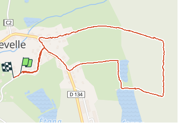
Trail Walking of 3 km to be discovered at Bourgogne-Franche-Comté, Haute-Saône, Franchevelle. This trail is proposed by PatriceCocuaud.
Positioning
Country:
France
Region :
Bourgogne-Franche-Comté
Department/Province :
Haute-Saône
Municipality :
Franchevelle
Location:
Unknown
Start:(Dec)
Start:(UTM)
309608 ; 5290324 (32T) N.
Comments