


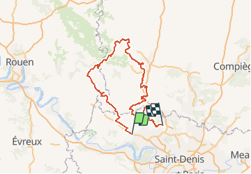
Tracé 003

olivieraron
User

Length
224 km

Max alt
229 m

Uphill gradient
2581 m
Km-Effort
259 km

Min alt
25 m

Downhill gradient
2658 m
Boucle
No
Creation date :
2020-05-17 15:18:20.204
Updated on :
2020-05-20 15:53:44.385
6h00
Difficulty : Easy

FREE GPS app for hiking
 SityTrail
IGN / Geographical institutes
SityTrail Plus
The world is yours!
About
Trail Motorbike of 224 km to be discovered at Ile-de-France, Val-d'Oise, Sagy. This trail is proposed by olivieraron.
Positioning
Country:
France
Region :
Ile-de-France
Department/Province :
Val-d'Oise
Municipality :
Sagy
Location:
Unknown
Start:(Dec)
Start:(UTM)
425689 ; 5435098 (31U) N.
Comments