


marais delincourt

bendoush
User
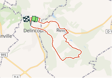

Length
7 km

Max alt
144 m

Uphill gradient
106 m
Km-Effort
8.4 km

Min alt
74 m

Downhill gradient
102 m
Boucle
Yes
Creation date :
2020-05-17 13:28:27.611
Updated on :
2020-05-17 15:42:57.343
2h01
Difficulty : Very easy

FREE GPS app for hiking
 SityTrail
IGN / Geographical institutes
SityTrail Plus
The world is yours!
About
Trail Walking of 7 km to be discovered at Hauts-de-France, Oise, Delincourt. This trail is proposed by bendoush.
Positioning
Country:
France
Region :
Hauts-de-France
Department/Province :
Oise
Municipality :
Delincourt
Location:
Unknown
Start:(Dec)
Start:(UTM)
414870 ; 5455299 (31U) N.
Comments