


Chapias est

pb07
User
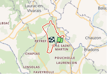

Length
9.9 km

Max alt
254 m

Uphill gradient
120 m
Km-Effort
11.5 km

Min alt
209 m

Downhill gradient
119 m
Boucle
Yes
Creation date :
2020-05-17 13:09:45.086
Updated on :
2020-05-17 16:27:57.131
3h17
Difficulty : Easy

FREE GPS app for hiking
 SityTrail
IGN / Geographical institutes
SityTrail Plus
The world is yours!
About
Trail Walking of 9.9 km to be discovered at Auvergne-Rhône-Alpes, Ardèche, Labeaume. This trail is proposed by pb07.
Positioning
Country:
France
Region :
Auvergne-Rhône-Alpes
Department/Province :
Ardèche
Municipality :
Labeaume
Location:
Unknown
Start:(Dec)
Start:(UTM)
604689 ; 4925698 (31T) N.
Comments