


Le Beout par la cité St Pierre fait le 17/05/20

mitch1952
User
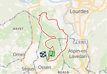

Length
8.3 km

Max alt
782 m

Uphill gradient
387 m
Km-Effort
13.5 km

Min alt
426 m

Downhill gradient
400 m
Boucle
Yes
Creation date :
2020-05-17 06:01:24.323
Updated on :
2022-06-07 09:49:27.327
2h31
Difficulty : Medium

FREE GPS app for hiking
 SityTrail
IGN / Geographical institutes
SityTrail Plus
The world is yours!
About
Trail Walking of 8.3 km to be discovered at Occitania, Hautespyrenees, Ossen. This trail is proposed by mitch1952.
Positioning
Country:
France
Region :
Occitania
Department/Province :
Hautespyrenees
Municipality :
Ossen
Location:
Unknown
Start:(Dec)
Start:(UTM)
738971 ; 4773146 (30T) N.
Comments