


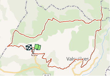
Herault - Dio La chapelle St-Amans 17km 370m

RandoVal
User

Length
16.5 km

Max alt
685 m

Uphill gradient
476 m
Km-Effort
23 km

Min alt
310 m

Downhill gradient
477 m
Boucle
Yes
Creation date :
2020-05-18 06:37:17.434
Updated on :
2020-05-18 06:41:00.357
--
Difficulty : Unknown

FREE GPS app for hiking
 SityTrail
IGN / Geographical institutes
SityTrail Plus
The world is yours!
About
Trail Walking of 16.5 km to be discovered at Occitania, Hérault, Dio-et-Valquières. This trail is proposed by RandoVal.
Description
Boucle dans le Lodèvois , départ et parking devant le gite Lou Castellou, sens horaire. Montée vers le plateau des éoliennes par la piste, passage à la chapelle St Amans, retour par le GR7 et l'église.
Positioning
Country:
France
Region :
Occitania
Department/Province :
Hérault
Municipality :
Dio-et-Valquières
Location:
Unknown
Start:(Dec)
Start:(UTM)
516889 ; 4835177 (31T) N.
Comments