


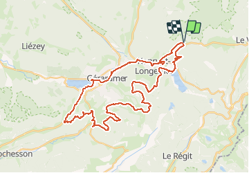
ROUTE DES 17

surceneux
User

Length
41 km

Max alt
1042 m

Uphill gradient
830 m
Km-Effort
52 km

Min alt
655 m

Downhill gradient
830 m
Boucle
Yes
Creation date :
2020-05-18 06:54:27.133
Updated on :
2020-05-18 10:41:51.05
2h55
Difficulty : Easy

FREE GPS app for hiking
 SityTrail
IGN / Geographical institutes
SityTrail Plus
The world is yours!
About
Trail Mountain bike of 41 km to be discovered at Grand Est, Vosges, Ban-sur-Meurthe-Clefcy. This trail is proposed by surceneux.
Description
SURCENEUX LONGEMER ROUTE DES 17 BAS RUPTS COL CHEMIN DE L'URSON SAPOIS COL RAMBERCHAMP GERARDMER SURCENEUX
Positioning
Country:
France
Region :
Grand Est
Department/Province :
Vosges
Municipality :
Ban-sur-Meurthe-Clefcy
Location:
Unknown
Start:(Dec)
Start:(UTM)
347845 ; 5329055 (32U) N.
Comments