


cote

michelelfn
User
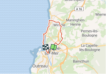

Length
16.4 km

Max alt
95 m

Uphill gradient
184 m
Km-Effort
18.8 km

Min alt
0 m

Downhill gradient
183 m
Boucle
Yes
Creation date :
2020-05-18 11:47:13.079
Updated on :
2020-05-18 15:24:04.242
3h19
Difficulty : Very easy

FREE GPS app for hiking
 SityTrail
IGN / Geographical institutes
SityTrail Plus
The world is yours!
About
Trail Walking of 16.4 km to be discovered at Hauts-de-France, Pas-de-Calais, Boulogne-sur-Mer. This trail is proposed by michelelfn.
Positioning
Country:
France
Region :
Hauts-de-France
Department/Province :
Pas-de-Calais
Municipality :
Boulogne-sur-Mer
Location:
Unknown
Start:(Dec)
Start:(UTM)
401685 ; 5619832 (31U) N.
Comments