Trail Other activity Würenlos - ZKB-Longjogg Lang1 So 6.4.2008 - Photo

ZKB-Longjogg Lang1 So 6.4.2008

© OpenStreetMap contributors
Length
Length
19.5 km
Max alt
Max alt
846 m
Uphill gradient
Uphill gradient
789 m
Km-Effort
Km-Effort  
30 km
Min alt
Min alt
442 m
Downhill gradient
Downhill gradient
789 m
Boucle
Boucle
Yes
Creation date :
2014-12-11 00:00:00.0
Updated on :
2014-12-11 00:00:00.0

(0 Reviews)

Other activity
Other activity
--
Difficulty : Unknown

Scan this QR Code to open this trail in the SityTrail application

FREE GPS app for hiking

Logo SityTrail SityTrail

IGN / Geographical institutes

Download SityTrail from the App Store Download SityTrail from Google Play

Logo SityTrail SityTrail Plus

The world is yours!

Download SityTrail from the App Store Download SityTrail from Google Play Download SityTrail on Huawei AppGallery

About

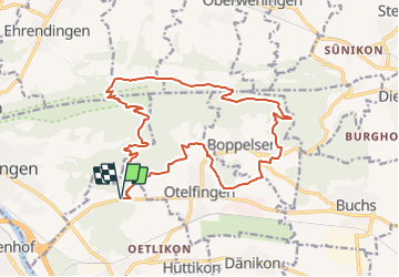
Trail Other activity of 19.5 km to be discovered at Aargau, Bezirk Baden, Würenlos. This trail is proposed by BAU47KURT.

Description

jogging Runde: Ried bei Otelfingen - Schützenhaus Otelfingen - Rebberg Otelfingen - Boppelsen Ost - Lägernhang - Hochwacht - Bergwiesen -Burghorn - Greppe - Ried b.O.
Ried b. O. ist an der Abzweigung alte Otelfingerstrasse Richtung Wettingen,

Elevation profile

Positioning

Country:
Switzerland
Region :
Aargau
Department/Province :
Bezirk Baden
Municipality :
Würenlos
Location:
Unknown
Start:(UTM)
452141 ; 5256401 (32T) N.


Close
My subscriptions