


Moisenay190520 15KM

fmg
User
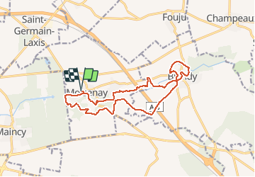

Length
14.8 km

Max alt
91 m

Uphill gradient
181 m
Km-Effort
17.2 km

Min alt
59 m

Downhill gradient
181 m
Boucle
Yes
Creation date :
2020-05-19 06:23:44.364
Updated on :
2020-05-20 12:37:41.31
3h38
Difficulty : Easy

FREE GPS app for hiking
 SityTrail
IGN / Geographical institutes
SityTrail Plus
The world is yours!
About
Trail Walking of 14.8 km to be discovered at Ile-de-France, Seine-et-Marne, Moisenay. This trail is proposed by fmg.
Description
passages boueux possibles en période de pluie

Positioning
Country:
France
Region :
Ile-de-France
Department/Province :
Seine-et-Marne
Municipality :
Moisenay
Location:
Unknown
Start:(Dec)
Start:(UTM)
480322 ; 5378847 (31U) N.
Comments