


colombier sabran colombier

Dan30
User
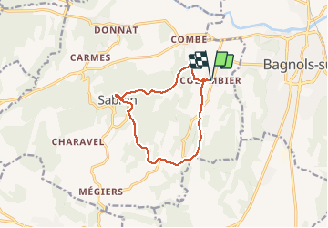

Length
11.8 km

Max alt
278 m

Uphill gradient
273 m
Km-Effort
15.4 km

Min alt
81 m

Downhill gradient
273 m
Boucle
Yes
Creation date :
2020-05-19 08:01:50.756
Updated on :
2020-05-19 11:59:50.167
3h36
Difficulty : Easy

FREE GPS app for hiking
 SityTrail
IGN / Geographical institutes
SityTrail Plus
The world is yours!
About
Trail Walking of 11.8 km to be discovered at Occitania, Gard, Sabran. This trail is proposed by Dan30.
Positioning
Country:
France
Region :
Occitania
Department/Province :
Gard
Municipality :
Sabran
Location:
Unknown
Start:(Dec)
Start:(UTM)
626610 ; 4890399 (31T) N.
Comments
rando très agréable. jolis sentiers.