


ZKB-longjogg Lang2 So 6.4.2008

BAU47KURT
User
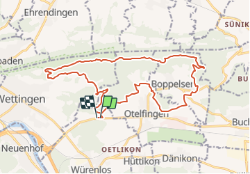

Length
20 km

Max alt
754 m

Uphill gradient
639 m
Km-Effort
29 km

Min alt
442 m

Downhill gradient
638 m
Boucle
Yes
Creation date :
2014-12-11 00:00:00.0
Updated on :
2014-12-11 00:00:00.0
--
Difficulty : Unknown

FREE GPS app for hiking
 SityTrail
IGN / Geographical institutes
SityTrail Plus
The world is yours!
About
Trail Other activity of 20 km to be discovered at Aargau, Bezirk Baden, Würenlos. This trail is proposed by BAU47KURT.
Description
Ried b. O. - Schützenhaus Otelfingen - Rebberg Otelfingen - Boppelsen Ost - Lägernhang Ost - Lagernhang West - Eigi - Greppe - Ried b. O.
Positioning
Country:
Switzerland
Region :
Aargau
Department/Province :
Bezirk Baden
Municipality :
Würenlos
Location:
Unknown
Start:(Dec)
Start:(UTM)
452248 ; 5256407 (32T) N.
Comments