


Balade Corona 1

mzonzon05
User

Length
9.1 km

Max alt
515 m

Uphill gradient
381 m
Km-Effort
14.2 km

Min alt
205 m

Downhill gradient
365 m
Boucle
No
Creation date :
2020-05-19 11:49:53.77
Updated on :
2020-05-19 14:47:14.271
2h56
Difficulty : Very easy

FREE GPS app for hiking
 SityTrail
IGN / Geographical institutes
SityTrail Plus
The world is yours!
About
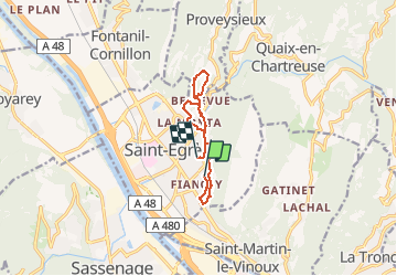
Trail Walking of 9.1 km to be discovered at Auvergne-Rhône-Alpes, Isère, Saint-Égrève. This trail is proposed by mzonzon05.
Positioning
Country:
France
Region :
Auvergne-Rhône-Alpes
Department/Province :
Isère
Municipality :
Saint-Égrève
Location:
Unknown
Start:(Dec)
Start:(UTM)
711331 ; 5011666 (31T) N.
Comments