


Marigny en Orxois du 19/05/2020

VANDERPUTTENMi
User GUIDE
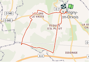

Length
8.8 km

Max alt
216 m

Uphill gradient
150 m
Km-Effort
10.8 km

Min alt
122 m

Downhill gradient
151 m
Boucle
Yes
Creation date :
2020-05-19 12:15:10.635
Updated on :
2020-05-19 18:36:48.12
2h40
Difficulty : Very easy

FREE GPS app for hiking
 SityTrail
IGN / Geographical institutes
SityTrail Plus
The world is yours!
About
Trail Walking of 8.8 km to be discovered at Hauts-de-France, Aisne, Marigny-en-Orxois. This trail is proposed by VANDERPUTTENMi.
Description
Un passage difficile avec des bourbiers d'animaux dans le chemin de Triquenique...
Photos


Positioning
Country:
France
Region :
Hauts-de-France
Department/Province :
Aisne
Municipality :
Marigny-en-Orxois
Location:
Unknown
Start:(Dec)
Start:(UTM)
516597 ; 5434216 (31U) N.
Comments