


Sentier des bornes

tiene
User
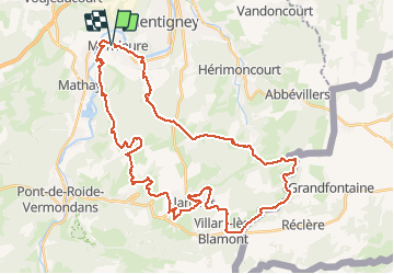

Length
44 km

Max alt
714 m

Uphill gradient
1115 m
Km-Effort
58 km

Min alt
324 m

Downhill gradient
1116 m
Boucle
Yes
Creation date :
2020-05-19 11:55:17.421
Updated on :
2020-05-20 07:03:38.127
3h37
Difficulty : Very easy

FREE GPS app for hiking
 SityTrail
IGN / Geographical institutes
SityTrail Plus
The world is yours!
About
Trail Mountain bike of 44 km to be discovered at Bourgogne-Franche-Comté, Doubs, Mandeure. This trail is proposed by tiene.
Positioning
Country:
France
Region :
Bourgogne-Franche-Comté
Department/Province :
Doubs
Municipality :
Mandeure
Location:
Unknown
Start:(Dec)
Start:(UTM)
334307 ; 5257741 (32T) N.
Comments