


canon cuvier

Yannick.Boireau
User
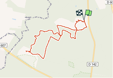

Length
9.6 km

Max alt
152 m

Uphill gradient
126 m
Km-Effort
11.3 km

Min alt
88 m

Downhill gradient
128 m
Boucle
Yes
Creation date :
2020-05-20 07:10:57.998
Updated on :
2020-05-20 10:24:07.661
3h09
Difficulty : Very easy

FREE GPS app for hiking
 SityTrail
IGN / Geographical institutes
SityTrail Plus
The world is yours!
About
Trail Walking of 9.6 km to be discovered at Ile-de-France, Seine-et-Marne, Fontainebleau. This trail is proposed by Yannick.Boireau.
Positioning
Country:
France
Region :
Ile-de-France
Department/Province :
Seine-et-Marne
Municipality :
Fontainebleau
Location:
Unknown
Start:(Dec)
Start:(UTM)
475271 ; 5367871 (31U) N.
Comments